![Item #16875 Elizabeth Jane. [Manuscript polar projection map of the Northern Hemisphere.] Esholt Hall [Yorkshire:], October 21, 1807. [With:] Crompton, Henrietta Matilda. [Manuscript map of Asia.] Esholt Hall [Yorkshire:], May 1808. [With:[ Crompton, Mary F[rances]. [Manuscript polar projection map of the Southern Hemisphere.] Esholt Hall [Yorkshire:], 1807. Elizabeth Jane Crompton.](https://mrtbooksla.cdn.bibliopolis.com/pictures/16875.jpg?width=768&height=1000&fit=bounds&auto=webp&v=1630432961)
![Elizabeth Jane. [Manuscript polar projection map of the Northern Hemisphere.] Esholt Hall [Yorkshire:], October 21, 1807. [With:] Crompton, Henrietta Matilda. [Manuscript map of Asia.] Esholt Hall [Yorkshire:], May 1808. [With:[ Crompton, Mary F[rances]. [Manuscript polar projection map of the Southern Hemisphere.] Esholt Hall [Yorkshire:], 1807.](https://mrtbooksla.cdn.bibliopolis.com/pictures/16875_2.jpg?auto=webp&v=1630432961)
![Elizabeth Jane. [Manuscript polar projection map of the Northern Hemisphere.] Esholt Hall [Yorkshire:], October 21, 1807. [With:] Crompton, Henrietta Matilda. [Manuscript map of Asia.] Esholt Hall [Yorkshire:], May 1808. [With:[ Crompton, Mary F[rances]. [Manuscript polar projection map of the Southern Hemisphere.] Esholt Hall [Yorkshire:], 1807.](https://mrtbooksla.cdn.bibliopolis.com/pictures/16875_3.jpg?auto=webp&v=1630432927)
![Elizabeth Jane. [Manuscript polar projection map of the Northern Hemisphere.] Esholt Hall [Yorkshire:], October 21, 1807. [With:] Crompton, Henrietta Matilda. [Manuscript map of Asia.] Esholt Hall [Yorkshire:], May 1808. [With:[ Crompton, Mary F[rances]. [Manuscript polar projection map of the Southern Hemisphere.] Esholt Hall [Yorkshire:], 1807.](https://mrtbooksla.cdn.bibliopolis.com/pictures/16875_4.jpeg?auto=webp&v=1630432927)
![Elizabeth Jane. [Manuscript polar projection map of the Northern Hemisphere.] Esholt Hall [Yorkshire:], October 21, 1807. [With:] Crompton, Henrietta Matilda. [Manuscript map of Asia.] Esholt Hall [Yorkshire:], May 1808. [With:[ Crompton, Mary F[rances]. [Manuscript polar projection map of the Southern Hemisphere.] Esholt Hall [Yorkshire:], 1807.](https://mrtbooksla.cdn.bibliopolis.com/pictures/16875_5.jpeg?auto=webp&v=1630432927)
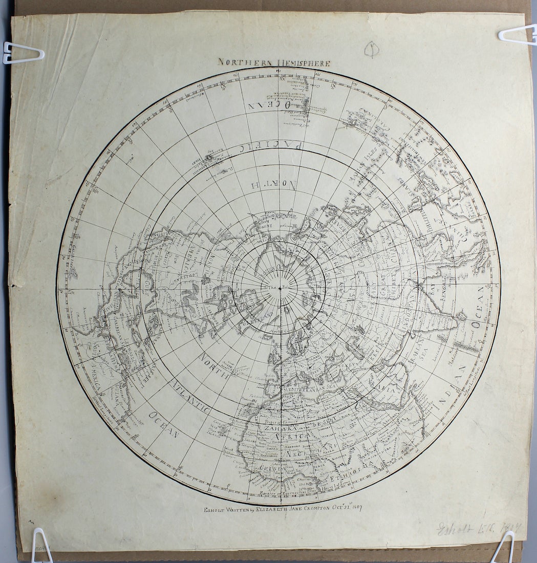
Elizabeth Jane. [Manuscript polar projection map of the Northern Hemisphere.] Esholt Hall [Yorkshire:], October 21, 1807. [With:] Crompton, Henrietta Matilda. [Manuscript map of Asia.] Esholt Hall [Yorkshire:], May 1808. [With:[ Crompton, Mary F[rances]. [Manuscript polar projection map of the Southern Hemisphere.] Esholt Hall [Yorkshire:], 1807.
These are unique items, most likely based on the maps of contemporary English cartographers. A possible source is James Wyld the Elder (1790 – 1836), who was known for his prompt publications of newly updated maps. Also note that, while the polar projection of the Southern Hemisphere is signed with the name of Mary Frances Crompton, the handwritten text on the map itself may be in Elizabeth’s hand. The two might have collaborated on the map or it may have been created by Elizabeth exclusively. The maps, drawn in black ink, are very detailed, with delicate hatchwork and careful calligraphy. On paper watermarked “E&P 1801” for the papermaking firm Edmeades and Pine. Small, circular holes in the centers of both polar projection maps (probably made by the artists to assist in making measurements). Some small tears to edges. One edge of the map of Asia has been reinforced on verso with document tape. Light intermittent dust soiling. A very good set of unique, richly detailed maps by three young women. Cream-colored paper illustrated on one side only. Three maps (two have the dimensions 19” by 16” and the other is 16 ” by 16 ”). Item #16875
The Crompton sisters’ maps reflect the contemporary boom in Pacific exploration that filled in the blank spots on European maps and, similarly, include areas in the interior of Africa and the South Pacific that are marked as “unknown” to the British. A notable absence from the map of the Southern Hemisphere is most of Antarctica, since the first confirmed landing on the Antarctic mainland did not occur until January of 1820. In addition, these maps are fairly early representations of the political geography of South Africa after British ousted the Dutch colonial government and reoccupied the colony in 1806. The names of the locations recorded, like “New Holland” rather than Australia and “Prince William Land” rather than King William Island, reflect the geographical understanding of the early nineteenth century.
The Crompton sisters’ maps reflect the contemporary boom in Pacific exploration that filled in the blank spots on European maps and, similarly, include areas in the interior of Africa and the South Pacific that are marked as “unknown” to the British. A notable absence from the map of the Southern Hemisphere is most of Antarctica, since the first confirmed landing on the Antarctic mainland did not occur until January of 1820. In addition, these maps are fairly early representations of the political geography of South Africa after British ousted the Dutch colonial government and reoccupied the colony in 1806. The names of the locations recorded, like “New Holland” rather than Australia and “Prince William Land” rather than King William Island, reflect the geographical understanding of the early nineteenth century. We could not find more information about Elizabeth and Mary in the sources available to us, but Henrietta never married and spent much of her life traveling through Britain and Europe. She was a skilled painter and illustrator who continued to study art throughout her life and took lessons from notable painters like Copley Fielding and David Cox. Several of Henrietta’s sketchbooks, as well as her letters and papers, are held by the Yale Center for British Art.
Price: $2,850.00